Many of the lands ACT has conserved welcome public use. Some privately owned properties are only open by invitation. As with any land, please respect the privacy and wishes of the landowners. Public use of private land is one of New Hampshire's greatest traditions - let's keep it that way!
Below are descriptions and directions to our conservation lands that welcome public enjoyment.
Sugar Hill, N.H.
3 connected PROPERTIES
Download a pdf of the trail map
Thanks to the generosity of several families, there are some great places to explore in Sugar Hill. Three properties, two owned by ACT and one privately owned and conserved with ACT, make up over 300 permanently protected acres for public (and wildlife) use!
The properties officially named the Foss Forest,
MacCornack-Evelyn Forest, and Bronson Hill Conservation Area are open to the public, but the Bronson Hill Conservation Area is privately owned so please respect space around the landowners' home.
You are invited to visit and walk the trails through the classic hardwood forest, out to a great view of the White Mountains, and explore wooded wetlands.
Please use caution when hiking on these or any trails in the North Country. For more information on hiker safety visit http://www.hikesafe.com/.
Foss Forest
This is the land that started ACT. Proposed for 10 house lots, today it is the keystone property of these three contiguously conserved lands. Foss Forest has trails on old skids roads and trails built by ACT volunteers and neighbors. Some of the trails lead onto the Bronson Hill Conservation Area and into the MacCornack- Evelyn Forest. The Foss Forest may be entered at a log landing on Pearl Lake Road, or from the end of Post Road.
MacCornack-Evelyn Forest
This land is adjacent to ACT’s Foss Forest, and was generously donated to ACT by the owners, Martha and Doug Evelyn and Martha’s brother Fred MacCornack. Martha and Fred wanted to follow their parents’ wishes to conserve the last of the family forestland. This was a significant gift to ACT adding to an already-conserved block or land with its rich forest habitat it harbors a variety of wildlife.
This land had long been treated as common land by its neighbors, even though it was privately owned. ACT invites the public to enjoy the land by walking, cross-country skiing, bird walking, and hunting. It had a rudimentary trail system when ACT acquired it, and the Trust has created new trails for public use. No motorized vehicle use is permitted other than equipment used for forestry and trail maintenance.The MacCornack-Evelyn Forest may be entered at a turn out on Hadley Road, or from the end of Post Road.
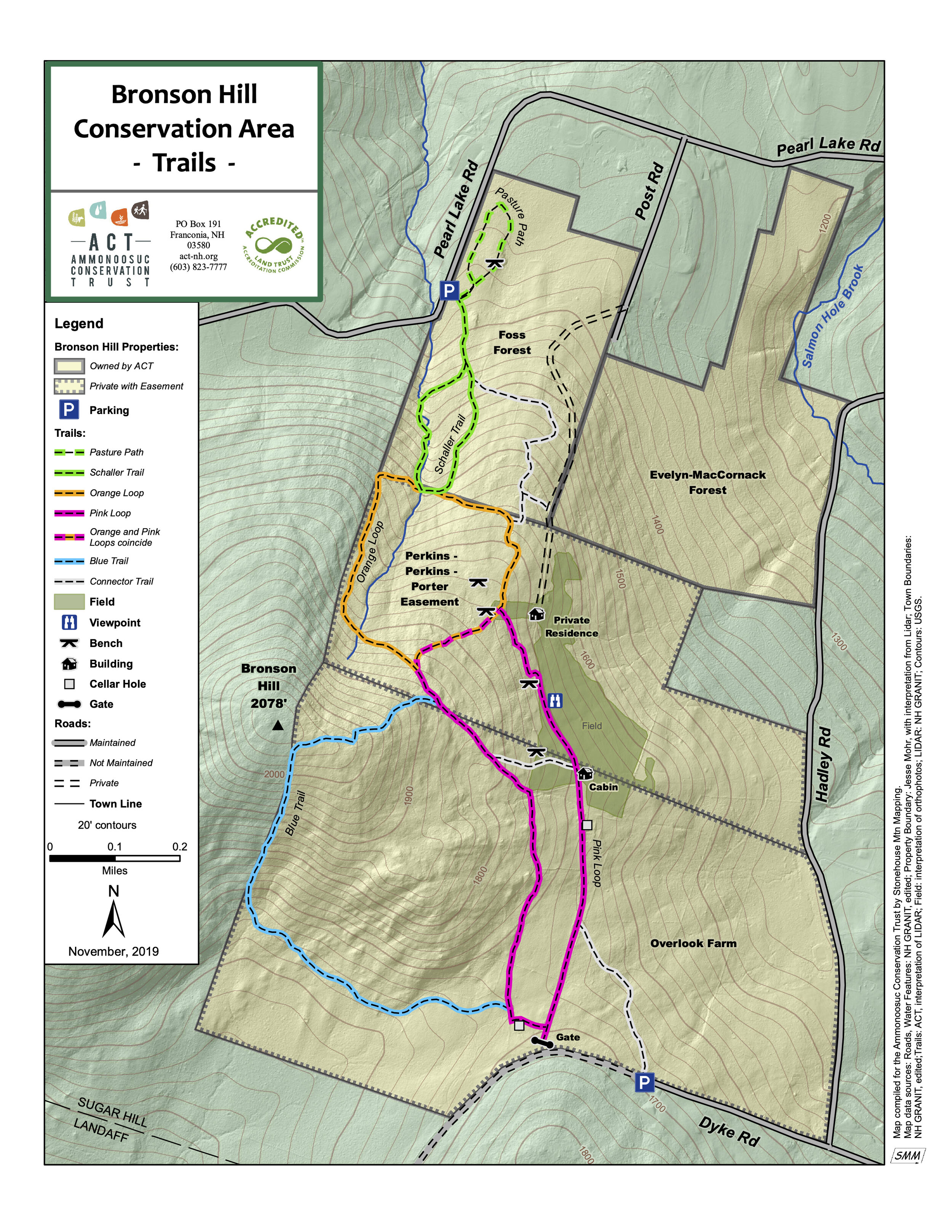
Bronson Hill Conservation Area
The Perkins/Gibbs/Andrews family has been part of the Sugar Hill community since the late 1800s, and the current generation felt strongly that these 128 acres of family land should be protected for future generations to enjoy. They made an enormous gift to the community of Sugar Hill, since Bronson Hill is consistently named as a top priority for protection in resident surveys.
The property is situated just below the summit of Bronson Hill and comprises a portion of the hill’s northern and eastern slopes – distinctly visible from Main Street, it helps give Sugar Hill its distinct rural character. Its trail system, maintained by one of the owners, is a great community resource and easily accessible from Hadley Road. The views from the property of the White Mountains, from the Presidentials through the Kinsmans, are unparalleled. The Bronson Hill Conservation Area can be accessed at a turn out on Hadley Road, or at the end of Dyke Road.
Herbert G. Whipple Conservation Area

With the generous support of more than 110 community members, ACT completed the purchase of the Whipple Farm land in the summer of 2005. The 20 acre plot, the last undeveloped land from one of Sugar Hill’s early farms, is located on Route 117 just up the hill from Polly’s Pancake Parlor. The trail can now be accessed behind Polly's, signage to be placed in summer of 2017. Overflow parking is near the red barn across the street from Polly's.
The land was cleared about 200 years ago and much of it has been maintained as field ever since. At its northern edge the property abuts a large beaver pond and marsh, most of which has also been conserved.
The land has not been actively farmed for many years, but has been mowed to provide habitat for field nesting birds and other wildlife. Its preponderance of native grasses also attracts an unusual variety of butterflies and moths.
ACT will maintain the land as it is today, mowing the fields in the fall to maintain the habitat for field nesting birds and other wildlife that require grassland for foraging, shelter, and breeding. Native grassland is a disappearing type of habitat in the region as old farm fields are abandoned and grow into forests or housing developments.
ACT invites the public to enjoy the Whipple Conservation Area land for walking, skiing, snowshoeing, etc. Each year during the summer we host an annual Bug & Butterfly Discovery Walk for kids.
Franconia, NH
LAWRENCE FOREST

Download a PDF of the trail map
The Lawrence Forest in Franconia has it all: steams, wetlands, floodplains, young and more mature forest, and views, all accessible from foot trails. The conservation commission had long been interested in the property for its excellent recreational potential – there are mountain bike/walk/ski paths there, and the land is close to or adjacent to other town-owned properties including Fox Hill.
The land, now called the Lawrence Forest, had been on and off the market for many years before ACT and the Franconia Conservation Commission worked together to acquire it. The 114.68 acres of undeveloped land along Beaver and Meadow Brooks was finally purchased by the town in 2016. ACT’s Clean Water/Healthy Trout initiative identified the Lawrence property as a high priority for conservation because of its two cold-water streams, floodplains, wetlands, and presence of native brook trout and red-nosed dace, a fish species on the state watch list.
ACT invites the public to enjoy the Lawrence Forest for walking, skiing, snowshoeing, etc. year round. Lawrence Forest is a great addition to the already formed trail network in Franconia. Parking is available at Fox Hill Park and some limited parking also available at the end of Old County Road.
Easton, NH
Cooley-Jericho Community Forest

Stunning views await you in the Cooley-Jericho Community Forest.
The property encompasses 840 acres in the northwest corner of Easton, sharing boundaries with Sugar Hill and Landaff. Highlighted by the prominent ridgelines of Cole Hill and Cooley Hill, this upland forest is one of the highest-elevation and largest privately-owned properties in the western White Mountains. It is spectacularly beautiful and rugged, with stunning views. It is accessible from Dyke Road, Trumpet Round Road, and Jericho Road in Sugar Hill, and from Jim Noyes Hill Road in Landaff. It may also be reached from the Jericho Trail on Route 116 in Easton.
Trail volunteers completed a 3-mile loop trail (blue trail) in the summer of 2016 which brings you up to the height of land on the property. Most recently our hard working volunteers cut and blazed a new connector trail over the Cole Hill summit adding just under a mile of trail to the overall network. This new trail (blazed in red) allows hikers to hike from blue to yellow (or vice-versa) making for a slightly longer loop hike!
Detailed descriptions of the trails can be found on the Cooley-Jericho Community Forest (CJCF) page on the Trail Finder website (trailfinder.info/trails/trail/cooley-jericho-community-forest).
The best parking access for the forest is from Trumpet Round Road, in Sugar Hill.

Click to download a PDF of the most up to date CJCF trail map. Please note that the Cole Hill connector trail on the map in green is blazed in red on site.

Context map of the Cooley-Jericho Community Forest.