

Reflections on Water - Chapter 2, A Land of Ice
Chris Nicodemus & Katrina Meserve
Our sensible hydrology reflects the regions “headwaters topography” coupled to northern New England’s climate that so frequently serves as the battleground between warm moist southern air and colder dryer northern air. In the first chapter of this series, we reviewed the bedrock topography of Northern New Hampshire in the context of geologic time to better understand the nature of the underlying bedrock and the valleys that form this northerly most watershed complex in New Hampshire. The bedrock not only determines the flow of surface waters into the valleys but serves as a reservoir for our water in the fissures and caverns that “may” exist below us in our various locations. However, in very recent geologic time our planet has been in an era of glaciation. There have been multiple expansions and contractions of continental ice sheets over the past several million years and the last extreme extent of glaciation across the contents occurred only 20,000 years ago. In the context of geologic time, 20,000 years is not different than “the present”. The continents are in the same relative positions and magnetic north is pretty much the same, but a few mountains, craters and islands have formed, and the sea level has risen. Twenty thousand years does extend back to pre-history in the context of humanity and civilization and while human cultures were already present across the planet at the peak of the last ice age, the continents were also dominated by the megafauna mammals that are mostly extinct today. Major glaciation events have occurred throughout the geologic history of the planet, that is best documented through analysis of marine sediments. Our current waning glaciation is known by geologists as the Quaternary glaciation cycling over the past 2.6 million years, being part of a longer glacial period known as late Cenozoic ice age that is marked by the persistence of continental glaciers over Antarctica partially for the past 34 million years.
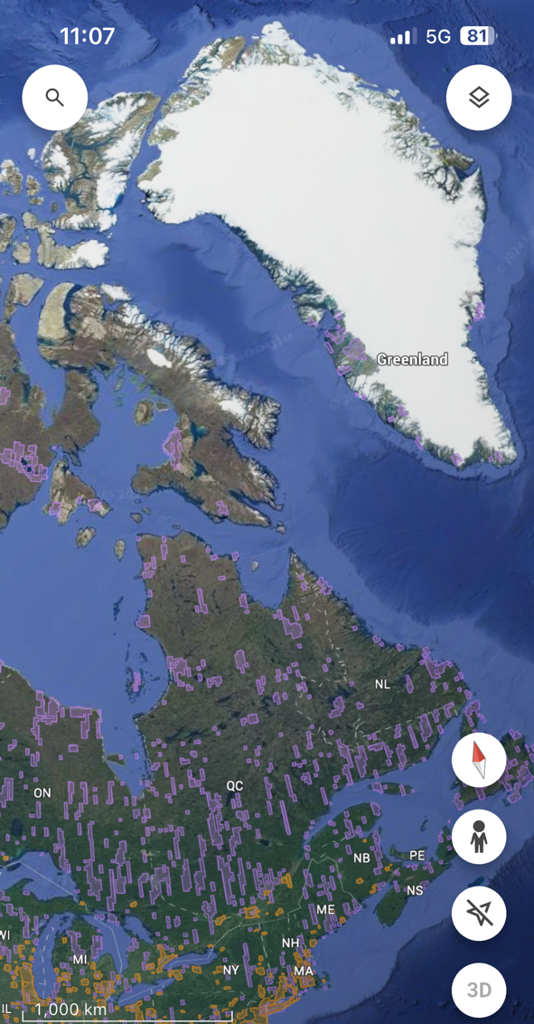
Glaciers 2024 (screen shot of Google Earth by CFN) Current View from New England north to Hudsons Bay and Greenland. North American Contental Glaciers arise in North Eastern Canada in the region surrounding Hudson’s Bay and extend outward.
Northern New England is in the mid latitudes on the eastern side of a continent adjacent to an ocean. A location halfway between the tropics and the polar region, it experiences a full range of heat and cold and plentiful precipitation. The region has been located under continental ice during extremes of glaciation and was so 20,000 years ago but emerged from the ice between 14,000 and 12,000 years ago. Not surprisingly our landscape and our groundwater are heavily influenced by the impact of glaciers. Considering that Greenland and Antarctica have “continental” ice sheets extant today, one can argue that the 21st century is still in the ice age. It is possible to experience a glacial landscape in the Alpine zones of Northern Grafton and Coös counties and “permafrost” still exists as frozen ground water in a few locations such as the ice gulch in Randolph. Mixed Northern hardwood forests are the natural succession to boreal forests dominated by black Spruce. Boreal forests still dominate select locations in Coös county and bare a strong resemblance to forests more prevalent well north of the St Lawrence Valley. These forests are testament to the relatively recent retreat of the continental glaciers.
Our understanding of the precise events associated with the formation and retreat of the continental glaciers as well as the cycles of glaciation is incomplete and not fully settled. For those of us with scientific backgrounds and careers in scientific disciplines, appreciation of the limitations of current knowledge is not surprising, and the diligent work of the scientific community will continue to better inform our understanding. We do know that during the current period of glaciation cycles of warming and retreat have been succeeded by cooling and expansion, but the precise sequence of events that governs these cycles is subject to debate.
In the carboniferous era that preceded the age of glaciation carbon dioxide and oxygen concentrations in the atmosphere were higher than they are now, ocean levels were higher. The abundant flora and fauna of that ancient era accelerated production of the organic material that has been incorporated over the eons into the hydrocarbon deposits of coal, oil, sandstone, marble etc that have been sequestered into the earth’s surface and below the oceans steadily since the beginning of time. It is only in the modern industrial era of the last few centuries that this carbon is now being released into the atmosphere and perhaps rewarming the planet back to a state that predates Cenozoic glaciation. A substantial fraction of carbon sequestration from the past billion years is potentially being reversed in a few centuries. Science cannot predict exactly what will happen, but the forces that influence available water will be operating under a new set of rules that we do not fully understand.

When conditions are right, culverts and narrow stream passages can be blocked and massive formations of ice that can overwhelm rods and fill gorges can occur. This scene from Bridal Veil Falls in Franconia February 2022, show how a “thawing rain” can result in massive ice formations in the cold snap that frequently follows. Here in Northern New Hampshire, the climate is currently far too warm for such ice to persist to the next winter and glaciers everywhere around the planet are in steady retreat.
Photo Credit Val Tassinari
In the 1990’s the US Geologic Survey New Hampshire regional office in Pembroke, performed a series of studies to document the nature of the stratified drift aquifers across New England. Sarah Flanagan’s report 94-4181 ([CN1]) provides a detailed assessment of the post glacial landscape in the middle Connecticut Valley including the Ammonoosuc Valley. The effort was a part of a desire at the federal level to better understand the water resources readily available to support regional populations. This reference describes in detail the geology left by the glaciation including the impacts on the underlying bedrock, the movement of surface rocks, the formation of glacial lakes as the glacier receded, and the movement of water and deposition of fines, sands, and gravels under the ice and in exposed glacial lakes. The sensible landscapes of the Connecticut and Ammonoosuc and Androscoggin Valleys reflect this process, and it is in the remnants of these glacial lakes and streams that much of the ground water available to the region resides.
Small Glaciers remained in the high country of the White Mountains as the wall of the continental ice sheet retracted approximately 12,000 years ago. The glacial retreat also included a short reverse period of cooling and a pause in in the retraction of the of the ice sheet referred to as the Younger Dryas period (reference Eusden, Geology of the White Mountains page 155). This pause in warming may have prolonged the presence of the transient post glacial lakes in the region that has also been associated with a period of caribou migrations and the presence of caribou hunting paleo-indians in the area.
A series of lakes formed and subsequently drained during this process. The underlying bedrock terrain was dammed with by deposited glacial sand, gravel and ice to form lakes that held levels for perhaps centuries before breaking through the earthen dams and lowering suddenly. Formations of sand deposited under the ice remain to the present time as eskers and drumlins and various level plains formed as silted lake bottoms that can be appreciated by the discerning observers throughout the region. The pre-historic Lake Franconia, for example, existed in multiple stages as its containing dams successively lowered. Water that initially flowed out southward to drain into the present Wild Ammonoosuc River near Benton, subsequently drained via the current day Salmon Hole Brook across the Sugar Hill Creamery Pond area, and then finally lowered further to follow the present-day Gale River through the ravine west of Ski Hearth Farm down to the Ammonoosuc in Lisbon. Level areas reflecting sedimented Lake bottoms at various heights of the Lake over time. Erosion canyons associated with the various drainages remain to the present as landscape features (reference Flanagan [CN1]). Meanwhile these glacial lakes percolated water deep into the bedrock below them and much of that water remains in the glacial till and the fractured bedrock to the present time.

Photo by CFN on a gloriously sunny cold winter day in Franconia. Cloud smoke or ash may be necessary to prevent sunlight from melting ice packs across the summer.
As regions become more arid, aquifers containing these earlier lake reservoirs remain for extended periods, but the surface waters diminish or disappear. In our region we continue to recharge our glacial and bedrock aquifers with our abundant precipitation. The USGS had special interest in the glacial aquifers for the work of Flanagan ([CN1]), because municipal wells must draw water in large volumes, and the high transmissivity of stratified drift aquifers make these formations a useful source of clean potable water for population centers. Many private wells that are drilled for individuals tap deeper into the bedrock aquifers hundreds of feet below the surface and below the superficial glacial levels. This provides reliable water supply to an individual, but such wells usually cannot draw water at rates sufficient to supply a municipal demand. Municipal water supplies typically come from surface water found in rivers and lakes and artificial reservoirs and in areas with glacial terrain from glacial ground waters tapped from stratified drift aquifers. Earlier in the settlement of northern New England, residents bult well houses on the hillsides surrounding their communities and tapped surface waters from streams and springs and shallow wells in the glacial terrain to supply the water for drinking and irrigation. Sandy glacial soils often drain and dry out very quickly such that even short periods without rain can result in very dry surface soils and impact resident vegetation
The legacy of the recent glaciation, and the abundant rainfall we receive have provided northern New Hampshire with a generous water supply, but the interactions of humans with our glacial till and our bedrock can impact the quality of water. Meanwhile changes in precipitation with climate change may impact our communities in a variety of ways. We will focus on climate in the next chapter.
[CN1] Reference US Geological Service, Pembroke NH 1996, Sarah M. Flanagan
Banner Photo by: EP Chow